
Client: Nuckolls County, Nebraska
The Challenge
A County Assessor is responsible for assessing and valuing properties within the county. Historically, valuing land parcels has been accomplished manually using a combination of paper maps, property record cards, soils books, and hard copy surveys. This disparate source material makes valuing land very difficult, time-consuming, and often inaccurate. Source documentation is often scattered across several county departments, preventing easy access and data sharing. In addition, the lack of public access to land ownership information creates further stress on the Assessor with increased phone calls and drop-ins from the general public requesting information. All of these things create a considerable strain on the Assessor and, in many cases, prevent her from effectively assessing the land. Nuckolls County, Nebraska, took the steps to address these issues by contracting with gWorks to create a land records geographic information system (GIS) for the County.
The gWorks Solution
A GIS is a digital map that displays many different kinds of data --such as parcels, soils, land-use--on one map so people can easily see and understand the data. These digital maps greatly simplify the process of maintaining, updating, and accessing parcel ownership information that was previously done by hand on paper cadastral maps. gWorks also integrates tax assessment and valuation software, often kept in a Computer Aided Mass Appraisal (CAMA) program, into the GIS, allowing users to instantly access the most up-to-date tax assessment records and other types of useful data associated with the digital parcels. What used to take an Assessor hours now takes seconds with a parcel-based GIS.
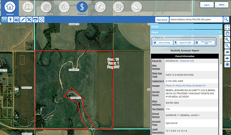
After gWorks constructed a GIS for Nuckolls County, we were able to leverage that investment by providing the County with a land records GIS website for greater access. This mapping website, or WebGIS, is a web-based interactive digital map that visualizes information in data layers. The website contains a single, visual repository of Assessor-related data that is accessible anywhere, anytime, and on any device to County officials and the public. A robust search allows the Assessor and the general public to easily locate any property on the map and view a complete property breakdown with the click of a button. A number of other tools are available, such as identify, measure, print, draw, and view photos to streamline workflow. The general public can access a variety of information in an easy-to-use interface 24/7, reducing the number of calls received by the County.
 The Benefit
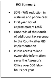
After building a GIS and making it accessible through a WebGIS, the Nuckolls County Assessor reports a dramatic increase in accuracy along with a significant reduction in walk-ins and phone calls from county residents. Since the GIS was implemented in 2010, Nuckolls County has averaged 17% property valuation growth annually, resulting in approximately $225,000 in new tax revenue generated in the first year after the implementation and $1.1 million in total new revenue through 2015. The County’s assessor directly attributes this growth to her GIS.
"By using the aerial imagery and the tools on the WebGIS site, we were able to see how the land was actually being used and find property improvements that hadn't been reported. Most of the corrections we found directly increased tax dollars for the County. " says Susan Rogers, Nuckolls County Assessor.
In addition to increased tax revenue through discovery, gWorks' WebGIS users across the Midwest save, on average, 500 labor hours a year in customer service requests from the public. Average customer service requests decrease by 60%. Other county departments can access the spatial data, which further leverages the investment in GIS and improves operational workflow across the entire county.
Using GIS at the local government level helps improve decision making and facilitates citizen engagement. Nearly all government data is location-based - managing this data through a GIS increases efficiency and accuracy. We know from our more than 300 government clients that when you make data visible with GIS, you discover unseen insights that empower effective action. Effective action equals a responsive, transparent government with long-term trust between it and the public. This journey begins with current and accurate data. gWorks' solutions bring together data, digital mapping, and simple software to deliver a powerful, cost-effective operational tool. We believe every government official should enjoy the benefits of precise data and GIS technology.